

You should learn a lot about the land before you start building. No matter if it’s a business, a house, or a road, it’s important to get exact measurements. They show you how to get around the site and where everything is.
It’s time to measure the land now. It gives engineers and construction crews the details they need to plan the work and make sure they stay on schedule while they’re doing it.
There are two types of surveying that can be used to find important parts of a site and measure land. Getting correct readings is what they both do, but they do it in different ways.
Building and road projects in the UAE are still just ideas, and the project teams need to make sure the spot is perfect.
We will talk about static and traverse surveys, where they can be used, and why they are useful.
For what reason do you need to do steady surveying?
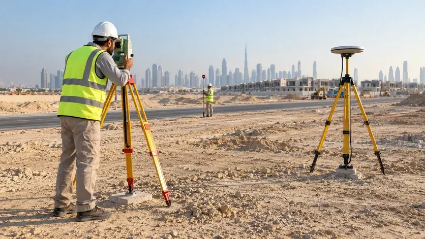
A static survey with satellites is one way to figure out how big a piece of land is. Set a GNSS sensor down somewhere and forget about it. It will get information from space. After that, the data is used to find that point.
This method helps surveyors set up accurate points of reference that they can use to find out how big other things are on a project site.
Check points might be set up first by surveyors who are getting a large area of land ready for building. They can use these spots to keep their coordinates the same for the whole job.
How does the Stay In Place Surveying method work?
It’s simple and only takes a few steps:
The inspector finds a good spot to take measurements.
Putting the gear together: A GNSS receiver is safely placed over the chosen spot.
Finding out things: The monitor stays put and writes down what the satellites see.
Going through the data: The coordinates of the point are found by going through the data that was collected.
The surveyor checks the numbers to make sure they meet the needs of the job.
What makes a static survey take longer is the site, the tools used, and how correct the results need to be.
When should you use flat surveys?
Many times, static surveying is used to set up control points for large areas of land, building projects, and improving public infrastructure.
What Does It Really Mean to “Traverse Survey”?
Engineers use a total station to find out where different points are by measuring the angles and lengths of survey stations that are joined together.
For this kind of work, a total station is often best. Experts use it to get correct readings of angles and distances, which they then use to figure out the coordinates of each point.
On a construction site, you may need to take measurements more than once along a road, the edge of a building, or the plan of the site. Traverse surveying connects these places so the survey team can figure out where they are.
Do you know what it means to survey in a traverse?
Before a traverse survey, these steps are usually taken:
One always starts from a known point of reference, no matter where they are.
Setting up the tool: At the survey station, a total station is set up and balanced.
An engineer keeps track of lengths and angles so they can find the next point.
Moving on to the next station: This will keep happening until all the points that need to be measured have been found.
With the measurements, the coordinates of the survey points can be found. This lets people know where things are.
The person who did the survey checks the numbers to make sure they are right and consistent once they get them.
This is a good way to send survey control across a site or along a building line.
What’s the Difference Between Looking Straight Ahead and Looking Around?
Both ways can give observers correct readings, but they do so in different ways.
To find a point on a static map, pictures taken from space are used. An angle and the distance between two places that are linked are used in traverse surveying.
A survey team could use static measuring to set up control points for a building job, for example. Then, traverse surveying can help them see the whole site more clearly, which will help them plan the building and get more accurate readings.
These things make them unique:
These days, GNSS units are mostly used for making static maps. To measure a traverse, most of the time, a total station and prism are used.
When you use traverse surveying, you measure angles and distances between stations. When you use static surveying, you get data from satellites.
The goal of static surveying is to set up safety points. Spatial surveying is used to get a better look at the whole site.
Things that must be true for static surveys to work: from space, it must be easy to see. It is necessary to have a clear view between the points being surveyed for traverse surveying to work.
You can pick the best method based on the project, the location, and the amount of accuracy you need. Sometimes it works best to use both at the same time.
Why is it important to see things that are moving and things that are not moving?
Land surveying done right helps builders understand a place better and make better plans for their work. Here are some of the main pros.
1. The right size of the space
Project teams need to know where the important spots are before they start building. These positions are set with the help of survey measurements that you can trust.
2. Making better plans that work
Survey information helps the builders decide where to put roads, buildings, utilities, and other structures, according to the project plans.
3. They didn’t make as many mistakes as they could have.
Setting out could be hard if you use the wrong measurements. You could also be late or have to do more work than planned. These kinds of risks can be lowered by doing thorough checks and surveys.
4. People in groups should work together more.
People in all three of these fields often work on the same project together. Survey control that is always the same makes it easier for everyone to work together. This is because all of them can use the same base points.
5. Help with a number of different jobs
There are different kinds of land surveys that can be used for different things, like building businesses, houses, and roads.
Fix and Move is how surveying is done in the UAE.
In the UAE, a lot of different building and road projects are being worked on. Businesses, neighborhoods, roads, and changes to factories are some of these. We can plan and do this job better if we know more about the area thanks to accurate surveying.
Plans to make the land better
Set up good reference points and measure a piece of land very well before it can be built on. It helps the project teams get the space ready for more planning and building.
Putting things together
Before putting something on a house, office, or business building, surveyors make sure that it fits with the approved plans and project coordinates.
Putting in roads and other public works
Make sure that roads, bridges, drainage systems, and utility networks are the right size and in the right place for them to work. If you want to set up points of reference, GNSS surveying can help. Traverse surveying can help you find your way around a job.
Sites for doing business and shopping
Large business and industrial developments may have a lot of buildings, roads that lead to them, and networks of service lines. Surveys about the site give them information that helps teams plan these parts.
Building and land surveys
Survey control points can also help you get more accurate measurements of land. They use the information to figure out how the space is set up and make plans that will work well there.
How do you choose the best way to survey?
You should plan what you want to measure and what you want to do with the survey results before you start the survey.
Take a look at these:
What size job is it?
For big projects, you may need GNSS-based control points, and traverse surveying can help you get readings from all over the site.
Situation on the ground: Buildings and other things that get in the way can block satellite signals. For traverse surveying to work, there also needs to be a clear line of sight between points.
Needs to be accurate: There are different readings that need to be taken for each job. The project should be able to use quality checks and polls.
Something that is already there to look back on: Control points have already been set up to help plan and carry out the study.
Available reference points: The measuring team can look at these things and give ideas on how to move the project forward. There are times when it makes sense to set up and grow site control using both static and traverse measuring.
Why should you get a surveyor to help you with your land?
Before you can start planning the building, you need to know the right things about the place. During the planning and building steps, things can go wrong if measurements are off or reference points aren’t checked properly.
Someone who is trained to do land surveys can help project teams find things on the site, set up good control points, and make sure that all of their numbers are correct.
If the study is done right, people who work in the UAE can plan better, work together better, and not have to do the same work twice.
Falcon 3D can be used for both static and traverse surveying.
In the UAE, are you going to build something or fix up land? If you start with correct survey results, you can figure out what to do next.
Falcon 3D ME can help you plan your land for many different projects. How should I do something? What matters is how big, where, and how accurate the project must be. This is always the case, whether you need survey control points or measurements taken all the way across a site.
The people who work here can help you figure out what kind of measuring you need and what options you have for your project.
Could someone help you measure for your next project?
Visit our page about our Static and Traverse Survey service to find out more about what we do.
Frequently Asked Questions
This measuring thing stays still. What do you use it for?
These satellites help us find a point in static mapping. It is often used to figure out where to start with building, land development, and infrastructure projects.
Why would you want to look at land by traverse?
By measuring angles and lengths, traverse surveying helps find the locations of linked survey points. It’s used a lot on building sites, roads, and other big projects that involve construction.
Is it possible to use static and traverse surveys at the same time?
Yes. With traverse surveying, you can set up control points. With static surveying, you can move those points around. It can be helpful to use both when the project calls for it and the site conditions allow it.

