
Advanced Intelligence
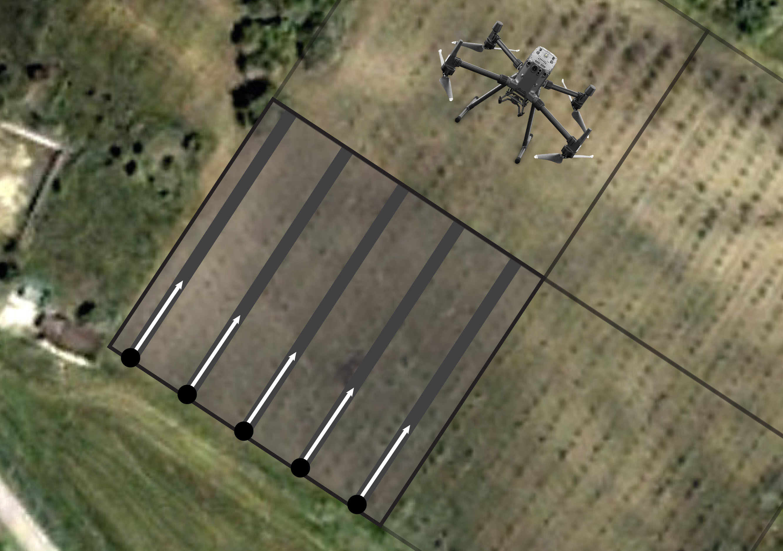
Record mission actions such as aircraft movement, gimbal orientation, photo shooting, and zoom level to create sample mission files for future automated inspections.
Drones can be equipped with high resulation cameras, heavy tripod, geo-location sensors, infrared sensors and many more to capture precise details about the environmental and physical site prior to and during construction. The high-resolution images captured by a drone are then turned into accurate 2D orthophotos and 3D models, creating a rich digital representation of your jobsite. Then, drone data platforms like 3DR Site Scan make it easy to overlay design files onto drone maps, enabling you to pinpoint constructability challenges in preconstruction, spot mistakes, and measure progress during construction.
Using a pre-planned drone services, drone inspection cost can be done automatically. The drone surveying services will autonomously follow the flight path and land safely after the mission is over with the push of a button. Automatic routine surveillance can be completed in a quarter of the time thanks to the reduction in man hours.
Drones enable solar panel energy maintenance – and hence overall cost – to be reduced by removing so much costly labor. The decreased price makes them more accessible to businesses and consumers, increasing demand. Inspection inefficiency and inaccuracy may be costly in any company; however, drone Services can intervene to prevent this from happening.
Other costly events can be avoided as well because a single faulty cell might put the entire system at risk. To get the highest potential performance and the most favorable return on investment, effective maintenance of the entire system, cell by cell, is essential.
We are dedicated to providing professional and reliable drone surveying services in Dubai. As a fully licensed drone operator in Dubai, we have the experience and expertise to handle any drone operation needs. We use the latest technology and equipment to ensure that our drone services meet the highest standards of safety and accuracy. Our drone operator in Dubai services are customized to meet the specific requirements of our clients.
We are combining services with Aerial Mapping Services and Survey Accuracy, Solar Panel Drone Inspection, Drone Surveying & Mining, Quarries & Aggregates, Drone Services, Drone Operator.

Progress of Construction Works can be provided accurately; Drone mapping can avoid the risks also.
READ MORE

Use Aerial Data to save cost and time in a variety of mining processes. Volume of Piles can be provided
READ MORE

Drone will Improve Safety, accuracy and efficiency on your solar energy projects
READ MORE

Safely and easily capture a high-resolutions Ariel
view of the Infrastructure in minutes

Make Topographical Maps of Huge/Hilly Areas
easily using our Drone Mapping Technology. Accurate results fastly

Solutions and formats, including contours, suited to more detailed applications.
READ MORE
Make Topographical Maps of Huge/Hilly Areas
easily using our Drone Mapping Technology. Accurate results fastly
READ MORE
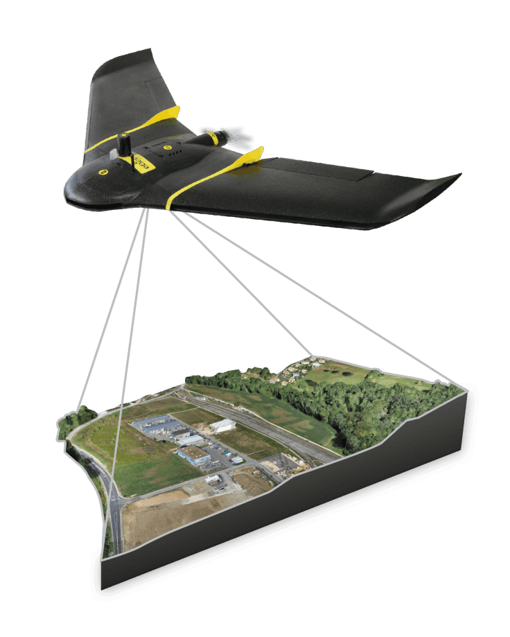
The eBee X is the fixed-wing drone for all your mapping needs. Designed to boost the quality, efficiency and safety of your data collection, it has a camera to suit every job, the accuracy and coverage to meet every project’s requirements, and can work virtually every type of site.
Enjoy vast coverage of up to 500 ha (1,235 ac) at 122 m by activating eBee X’s unique Endurance Extension
The eBee X allows you to work virtually every site, no matter how demanding, thanks to its space-friendly Steep Landing technology, ultra-robust design, live air traffic data and more—all backed by senseFly’s trusted professional, local support.
.
Record mission actions such as aircraft movement, gimbal orientation, photo shooting, and zoom level to create sample mission files for future automated inspections.
.
The refined airframe and propulsion system design gives you a more efficient and stable flight, even in harsh conditions.
.
Configure your Matrice 300 RTK to fit your mission needs. Mount up to 3 payloads simultaneously, with a maximum payload capacity of 2.7 kg.
DJI has rethought its drone technology from the ground-up, revolutionizing its systems to achieve a new standard for drone accuracy – offering Phantom 4 RTK customers centimeter-accurate data while requiring fewer ground control points.
.
The heart of the Phantom 4 RTK is its integrated real-time kinetic (RTK) positioning system, located in a node at the top of the drone. This technology allows for centimeter-level accuracy: 1 cm + 1ppm horizontally and 1.5 cm + 1ppm vertically.
.
In areas where signal reception is poor, the GNSS module that sits right underneath the RTK module takes over to allow the drone to maintain flight stability. With this redundancy, safe and optimal flight is ensured while continuing to collect precise and complete data for mapping and survey jobs.
.
The Phantom 4 RTK comes with the
standard 1-inch CMOS sensor to serve the mapping applications of the RTK.
Need to get a Quote.?

Locate Us
Suite #209, Apricot Tower
Dubai Silicon Oasis
P.O. Box 238544, Dubai
United Arab Emirates
Call Us: +971 4 327 1414(Dubai)
Call Us: +971 2 550 4300 (Abu Dhabi)
Our Services
LASER SCANNING SERVICES