Technology is growing quickly in both manufacturing and building right now. Spend some time planning and watching the job spot to make sure it gets done right. It might take longer and give you a less accurate picture of the space you want to work with the old-fashioned way of measuring.
Numerous companies now use 3D drone mapping services to make better plans for projects, cut down on wait times, and make better decisions.
As a result of new technology, businesses can quickly get correct information about a site, keep an eye on the building process, and create full 3D models of sites. Businesses can build or fix things faster, safer, and better with the help of drone scan services.
3D drone mapping is a new way to look at land. The shots and information about the land are taken by high-resolution cameras on drones.
This information is used to make 3D models of places.
Professional builders, engineers, and developers can use these high-resolution pictures to get a better idea of what the place looks like and plan their next steps.
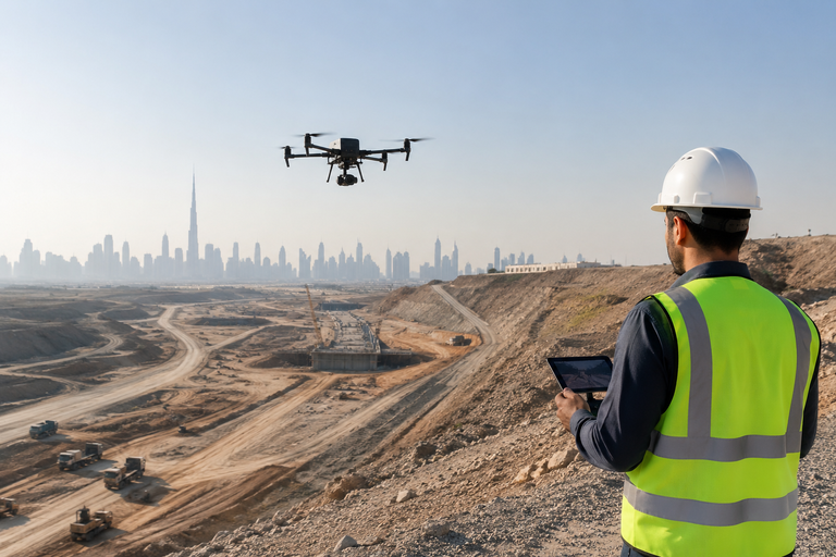
Large building sites can make a standard land survey take several days. Working with professional drone mapping services makes surveys go much more quickly and correctly.
It helps companies:
That is why project teams that use quick and accurate aerial survey services can get things done faster and make better decisions.
Getting the right measurements is an important part of any building or infrastructural job. It only takes one mistake to make things take longer and set you back more.
Companies can find out a lot about a place when they use drone surveillance technology. These facts help them:
Having good 3D planning survey responses makes it easier to finish a job from start to finish.
Aerial video services make it easy to see what you're looking at.
Not only can project teams use images and reports, but they can also see:
It is easier for engineers, workers, experts, and clients to talk to each other when they can see the sky like this.
There are a lot of checks to be done on building projects, so they stay on track. Drone survey services will enable teams to acquire regular information from above while the project is being carried out.
It’s beneficial for business:
Building drone mapping allows project managers to monitor large projects better and make better, faster decisions.
Sometimes it is dangerous to undertake inspections by hand at building and industry sites. It is safer because workers don't have to go into dangerous areas as much during drone mapping studies.
Unsafe places for drones to look are:
This keeps the workers safe while still getting correct data from the sky and full details about the area.
For digging, mining, and building on land, it is very important that the volume estimates are right.
Companies can use technology for mapping with drones to:
These exact measures help businesses cut down on waste, make better budgets, and keep project costs under better control.
Things move quickly on projects these days, and teams need to know what's new to be able to adapt to changes on the job site.
Today’s overhead info helps project teams work faster and minimize needless delays.
Now, 3D flyover mapping services are widely employed in various fields, including.
As tech becomes better and better, more and more organizations are engaging professional drone survey services to get their work done faster and more correctly.
3D drone mapping is causing Engineer and building projects to change their plans and dates. Drones help companies pick better projects by speeding up research, collecting better site data, making projects safer and letting managers monitor them more closely.
Companies nowadays are using drones to do jobs faster and better, save time and money and obtain more accurate results. There are several services, such as drone building inspections and aerial mapping.
As technology advances, more industries are utilizing high-tech measurement instruments, and drone mapping services are becoming an important aspect of project planning and site management. Call us today for more info.